ATMOSPHERIC PROJECT
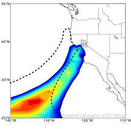
Physically-based Probable Maximum Precipitation (PMP) Project over three
watersheds in Northern California
A new methodology to estimate probable maximum precipitation (PMP) is developed by means of physically-based reional atmospheric model. The methodology is developed with application over the American River watershed, the Yuba River watershed, and the Upper Feather River watershed in Northern California. The developed methodology does not depend on observation data unlike traditional PMP approach or flood frequency analysis, and its final goal is to obatain the physical upper bound of prescipitation over the target watershed.
ENVIRONMENTAL PROJECT
Study of the Water, Sediment and Mercury Inflows to Cache Creek Settling Basin based on Cache Creek Watershed HydrologyandFuture Climate Conditions
Cache Creek Settling Basin (CCSB), located two miles east of Woodland, California, was constructed to preserve the floodway capacity of Yolo Bypass by entrapping sediment. Cache Creek is the main source of mercury entering San Francisco Bay-Delta. Entrapping sediment also entraps mercury, so the settling basin also helps preserve aquatic life of San Francisco Bay-Delta
HYDROLOGIC PROJECT
Upper Middle Fork Project
The Upper Middle Fork Project (UMF) project pilots coordinated implementation by two of the IRWM Plan signatories. Plumas County and the Sierra Valley Groundwater Management District each manage significant portions of the project area, but heretofore, have not attempted coordinated management for improved water quality. Future opportunities for enhanced coordination of land use plans, zoning and source water protection will be one outcome of the 12-24 water management scenarios that will be developed during the third year of the UMF project. The Upper Middle Fork project pilots the integration of local water management knowledge, local land and water use authorities, and the best available science to further our capacity to practice sustainable resource stewardship at the regional scale.


